Wednesday, March 12, 2014

Dead Horse State Park and Canyonlands National Park

Cayonlands had a few arches too. Slightly better view though.
November 25th, 2013

I woke up just after the sun rose to explore new territory. Unlike the last stop, I was completely unfamiliar with Cayonlands. I hadn't even heard of it until I saw a sign on my way to Arches. After a little research I also learned about Dead Horse Point, which was on the way to the park.

Dead Horse Point overlooks an area used to trap horses to be used as new mounts. It is an outcropping of rock that has a cliff on 3 sides with the Colorado River at the bottom. Riders could chase the horses out onto the rock, close the gate, and have their pick of the horses. On their way out, they would open the gate and let the horses out. Well, they forgot the second step once and the horses became trapped and died; thus the name.

It is supposed to have fantastic views, so I was a little disappointed when I got there and saw this:

Stupid cloud. And this was taken in a "clear" patch.
There were clouds hanging out in the valley! The whole way there I followed blue skies and the clouds picked the valley as their hangout. I was a little disappointed, but decided to wait it out for an hour to see if it cleared up at all. I pulled out my knife and worked on my walking stick for a bit, wandered around some other paths to snap some of the other photo sites.

So close to clear!


I finally called it and decided I would stop again on my way back to town. Maybe the mid-day sun would burn off the clouds.

Looks like I made the correct choice!
Canyonlands is a HUGE park. A quarter of a million square miles huge. I explored the Island in the Sky district of the park. I am not even sure about how you reach the other districts in the park because the road sort of ends. There are 4 wheel drive roads, which must be how you get around off the main road.

The views here are simply stunning. This is by far one of the coolest places I have visited on the trip.

Love the mountains in the distance.


There are a lot of hikes that take you down into the canyon. I never took any because most of the trails were covered with snow, and I was pretty sore from all the walking at Arches. I did hike the Grand View Point Overlook trail. It was super cool because you could look out over the clouds in the valley.

Welcome to the edge of the world.

Almost looks solid

View from the end of the trail

I also hiked out to Upheaval Dome. This is a pretty cool geological oddity that has a dome surrounded by a crater. There were a few theories as to how it formed including a meteorite impact and a collapsed salt dome. I don't think they ever spelled out what it was on the trail.


After Upheaval Dome, I was done hiking for the day. I made my way back to Dead Horse Point. I was lucky because the sun was setting and it changed the rock to a brilliant red color. If you can, spend sunset at Dead Horse. You won't be disappointed.

The setting sun really brings out the colors in the rock. (Still Canyonlands)


Dead Horse.
If I had a decent camera, I would take shots of this every second until sunset. The colors were much more vivid in person.
After the sun set, I made my way back to Moab for the night. New destinations awaited early the next morning.

Click here for more pictures of Dead Horse and Canyonlands

Monday, March 10, 2014

Arches National Park


November 24th, 2013

I woke up early and made my way down to Arches. It is a little bit weird driving a road in winter that you had driven only driven in the summer. Things look so familiar and yet so different. This morning was very jarring because the last time I was here it was 90 degrees in the shade.

I went right into the park (nearly empty this time around) and stopped to take a picture of the one hike Quinn and I did when we were last here. Not nearly as much vegetation or wildlife; not that there was much to begin with. I was also dealing with overcast skies and some fog.
Summer
Winter
I proceed further into the park to check out some of the other hikes and sights. There were a lot of balancing rocks. As you can probably imagine, these are pretty rare formations like the arches. Different layers of rock erode at different speeds. In a pillar, this can form a balancing rock. In a sheet, this can form an arch.

Click to get a bigger picture. See the "tree"?

Another cool formation was the "Sea of Sand". It is a lot easier to see in the summer without the snow cover, but there was an exposed section for the picture below. This was formed by a sand dune being compressed into rock. It covers a large expanse of the park and is really thick in some areas. It really makes you focus on how much time has passed since these rocks were formed.


The "main attraction" of the park, also its namesake, is of course the arches. Of which there were plenty. There were a lot of really short .3-.5 mile hikes to reach these giants.


One shelf can have multiple arches.

The black staining is either a chemical reaction or bacterial/fungal growth on the rock.


You can see the arch slowly growing as more of the rock cracks and breaks off.

This is a rare formation where the center of the shelf eroded and left an arch on either side of the shelf.
The next hike I picked was a bit longer and much more strenuous. The path was muddy, you walked up a giant tilted slab of rock, and there were sections where you were pretty close to the edge. The sights along the way and at the top were well worth the effort.

Preserved drawings. I can't remember how old they were.


I could sit here and relax for hours if the rock didn't suck all the heat from your body in a matter of minutes.

I wandered back to my car and made lunch. By "made lunch" I mean I ate chili from a can, cold, with some leftover rolls from the other day. As bad as that sounds it was rather filling and gave me a second wind for more hiking.

The next area I stopped at you can't hike through unless you get a permit or hike with a ranger. The hike itself is a full on maze, so if you are unprepared you can easily get lost. It is called the Fiery Furnace after the way the rocks appear brilliantly red in the sunset. Even with little sun, the rocks still looked amazing. It is on my list for next time.


I got in a few more short hikes before calling it a day. It had been a while since I had hiked this much in a single day and my body was starting to wear out. There were about 4-5 more arches that I didn't get to in my visit.

Not all arches have to be huge.

I think this one was called broken arch, since it has a crack in the middle.


This arch "recently" (within the last 100 years) got larger as a huge section of rock fell from the upper left hand side.
I wandered down to Moab for dinner and sleep. I stopped at the Moab brewing company for wings and beer. Other than the fact that they didn't have a beer flight to sample all their brews, it was alright. After a long day of hiking I crashed for the night.

Entrance to the park. The section of rock high on the left is the same rock that Arches is made from. The fault that runs through Moab dropped the arches side, creating all the formations.
Click here for more pictures of Arches.

Wednesday, February 5, 2014

Salt Lake City

Salt Lake City, UT
November 22nd, 2014

I had a long drive ahead of me as I made my way south. I was headed toward Bear Lake State Park in Utah. With the road through Yellowstone closed for the winter, I had to make my way around the park. US 119 took me through the mountains that surround Yellowstone. The area is loaded with campsites, most closed for the winter, that serve as overflow for the park during the summer. The trees were covered with snow, the creek was still flowing, and the mountains were towering overhead. If you can't get into the park due to crowds, this would be a pretty nice alternative. It was also one of the more relaxing drives I have had.

Sunset in Montpelier, ID
I made it all the way to Montpelier before I checked the weather forecast for the area. Unfortunately the weather was not going to cooperate and it was going to drop to 5° that night, well below my sleeping bags limits. I wasn't even sure that the Bear Lake had campsites available, so I stayed in Montpelier.

Lights behind my hotel for the night
There wasn't much to do in the town, but there was a giant M behind my hotel. I am not sure if it was for the High School, or something else, but I counted them as the first Christmas lights of the season.

Bear Lake State Park
The next morning I made the quick trip down to check out Bear Lake. On the way there, the land was mostly flat, which was a vast difference from the mountainous terrain I was used to. Then, as if appearing out of nowhere, was a giant lake with mountains off in the distance.

It is very much a summer destination and it was mostly abandoned while I was there. The docks were mostly empty, with one or two boats for emergencies. There was no ice in the lake, but I am sure it was far too cold to swim in. The whole area seemed very touristy, like a summer destination for everyone who lived in Salt Lake City. After taking a few pictures by the lake and on top of the mountains on the way out, I made my way towards Salt Lake City.


I had to pass through Uinta-Wasatch-Cache National Forest on my way to Salt Lake City. It was another wooded, winding road through the mountains, which was really relaxing. There was even a ski hill tucked in there, making me wish I had brought my snowboard gear.
Logan, UT
After leaving the national forest, you are greeted with this view in Logan, UT. You are high up overseeing the valley with some mountains off in the distance. I sat in my car and looked around for a few minutes. It is hard to believe there wasn't anyone else stopping to enjoy the view. They must be used to it.

Mormon Headquarters: The Church of Jesus Christ of Latter-day Saints.
I arrived in Salt Lake City shortly after noon. I walked around the church square, which took up quite a large portion of the city. I didn't go inside any of the buildings because a wedding was going on and I didn't think they would appreciate an underdressed onlooker.

I walked around the outdoor mall looking for a decent place for lunch. I eventually pulled out my phone and used Yelp to find Spitz.

Spitz SLC
One of the things I was spoiled with back in Dearborn was Shawarma. I hadn't really had anything remotely close to as good until I stopped at Spitz. Not only was it good Shawarma, it ranked up there with some of the best from Dearborn. Stuffed, I made my way out of the city and continued south.

Salt Lake City was located at a crossroads for me. I had two paths that I could take: I could go east and revisit Arches National Park, or I could head west and visit Zion. I decided that if I was going to revisit Arches, I should likely see if there was anything else around to see. I noticed that Canyonlands was essentially right next to Arches, so Arches won out.

I made it as far as the rest area before US 191, pulled in, and slept in my car for the night.

Pictures of Salt Lake City

Tuesday, February 4, 2014

Yellowstone National Park

It was about 5° outside, and the water coming out can be upwards of 150°.
November 21st, 2013

I didn't leave Riverside until after lunch, so I only had a few hours of driving before it started to get dark. I made it through Idaho and into Montana just after it got dark. I spent the night in Butte, determined to get an early start and make it to Yellowstone the next day.

It was such a dark night that I completely missed the fact that my hotel was surrounded by mountains when I woke up. It is hard to imagine giant mountains being anything remotely close to "sneaky", and yet they nearly took my breath away when I started the car.

I did indeed get my early start, but as I had come to expect not everything in my journey was going to go as smooth as planned. There has been a lot of talk this year about the "Arctic Vortex", caused by the jetstream being pushed south. I happened to be on I-90, west of Bozeman, MT when this happened back in November. The skies went from clear to less than 15 feet of visibility. Traffic nearly came to a complete hault. I limped along on the road to Livingston, where I would need to turn and head south to get to Yellowstone.

Not wanting to push my luck with the storm, I stayed at the Super 8. If you are ever in Livingston, I highly recommend staying there. Great rooms, low price, nice staff, plenty of coffee. By the next morning, the storm had cleared and I was able to make my way south.

Yellowstone is a BIG park. So big, in fact, that they are not able to keep the entire park's road system open all year round. When I was there, only the northernmost road was open, while the rest was limited to the rangers. This means that if I wanted to go see Old Faithful I would have a 60 mile round trip hike from the closest place I could park. I will let that wonder wait until I come back to visit in the summer months...

Approximately parallel with Traverse City, MI!
One of the first sights upon entering the park was a river that ran next to the road. It was a super cold day due to the jetstream, so it was a little odd not seeing any ice flowing down the river. There were signs posted next to the river warning people not to go in (not that I was tempted at all). Upstream the river met with a hot spring, so the water temperature was upwards of 150°. Not something you wanted to use for a quick dip.
The river is partially fed by a hot spring, so you could see green vegetation in the river with snow on the bank!
One of the areas still accessible was the Mammoth Hot Springs. Most of the businesses up there (gas station, hotel, general store) were closed, but you could still walk on the platforms surrounding the springs.

Liberty Cap: dormant hot spring cone
 There were many formations, like the cone above, to go and see. They are formed by minerals brought up from the springs and deposited on the surface. The springs aren't fixed, and some of the paths up to the surface can become dormant for years before flowing again. The whole area is pretty volatile and reminds you that Yellowstone is still a very active volcano.

Some of the walkways took you almost down to water level. The steam rising up from these smelled just like the hot springs that I was able to lounge in back at Olympic. With the day being as cold as it was, I was wishing for a nice relaxing soak.

The deposits formed little plateaus. 
View from the upper springs
Waterfall hidden at the end of the trail.
After exploring the springs and taking a nice hike, I made my way east. Since only the northern road was opened, I tried to see everything that was available to me in a single day. After I left the hot spring area, I started to see some wildlife. There were lots of buffalo, a few foxes, a wolf, and lots of deer. I didn't see any elk, but I think they prefer a different area during the colder months.

Buffalo!
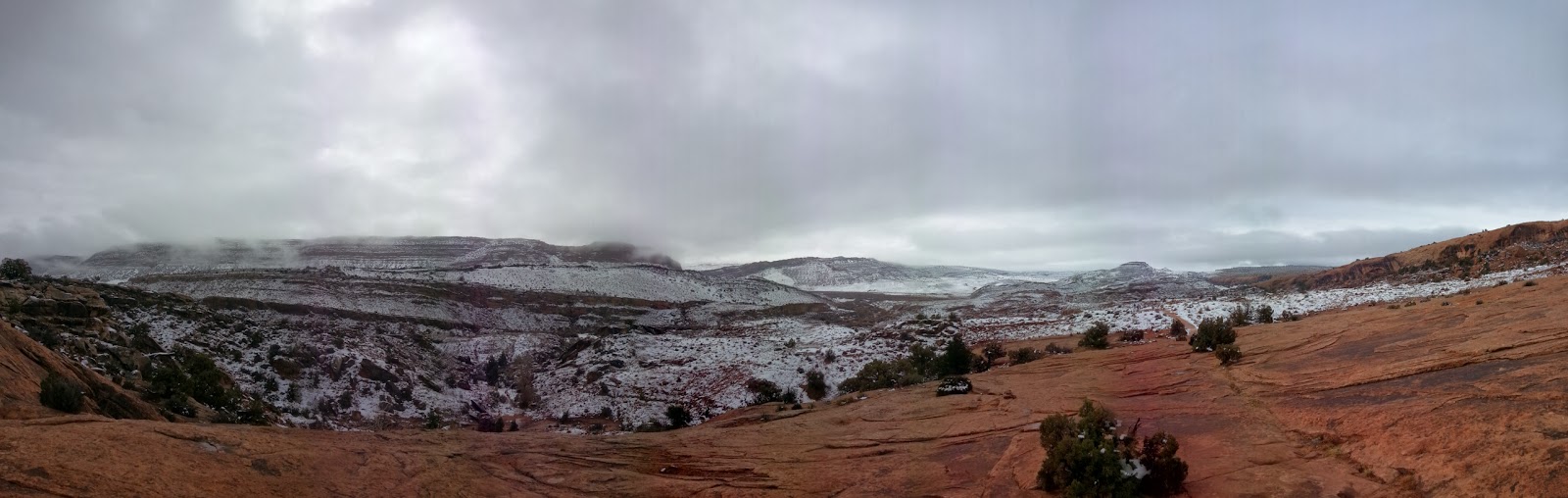
The road east changed elevation quite a few times. The environment was also different, between heavily forested areas and wide open plains. There were a few hidden lakes and watering holes, as well as evidence from the last eruption of Yellowstone. It was absolutely stunning.

Everywhere I looked there were great panorama shots!
Taken from a bridge crossing the Yellowstone River

I made it as far as I could east before turning around. The roads were beginning to get really icy as the trees got closer to the road. Since I was going to need to head west to continue my journey, I backtracked to Livingston. I was able to enjoy the sun setting over the mountains and changing the scenery the entire way back.

The last picture I was able to snap before it really got dark.
Again, this is an area of the country that pictures just do not do it justice. I can see why people spend weeks out here during the summer. I intend on coming back to visit and seeing everything I can.

Take a look at the pictures linked below, I have about 95 from the area.

Pictures of Yellowstone National Park